Wednesday, December 14, 2016

Detailed Map of Accotink Creek Watershed!

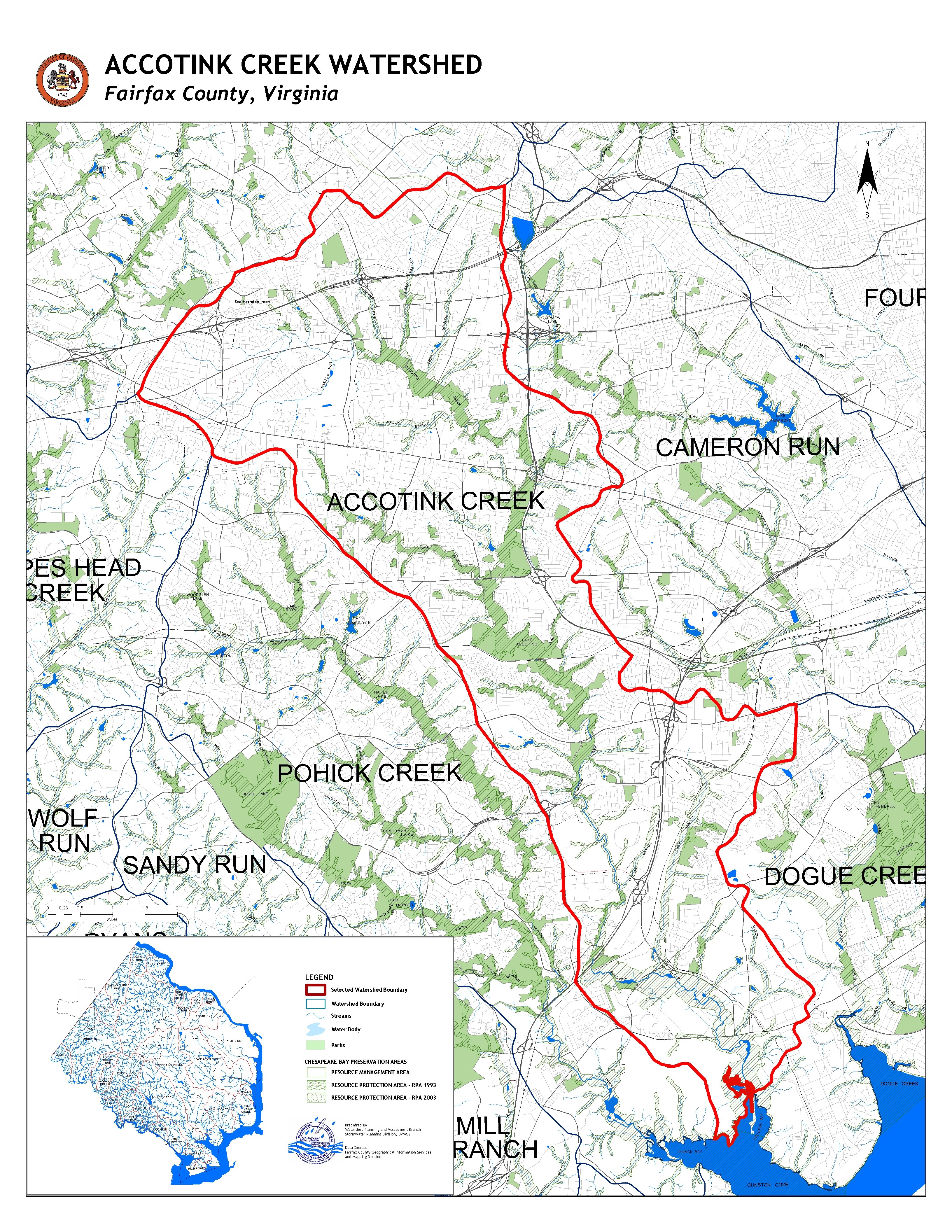
The below picture is in greater detail (maybe you can find your house!) if you follow this link.  This will hopefully allow you to enjoy in detail the areas that are explored within this blog. It has been a pleasure learning more about how my local watershed functions and how my families life has a direct impact on its well-being.  As long as I am a resident of the area I will continue to update this blog with my adventures exploring it and any volunteer work with Friends of Accotink Creek or on my own. 

If you'd like to volunteer your time maintaining the watershed or learn about how you can be a responsible watershed member please get in contact with me through this blog or Friends of Accotink Creek! 


Sunday, November 20, 2016

The Bane of the South - KUDZU!

Here is embedded the slide show I created on Kudzu which I heard my mother speak of often as a pest and she would point it out to me as we would be driving around town.  I never though I would be doing a slide show on it but I found out a lot of interesting things about Kudzu, specifically, how it was introduced to America.  Enjoy!


Saturday, November 5, 2016

Accotink Creek Restoration Plan Slide Show

After almost numbing my mind with the whole of Fairfax County's Accotink Creek Watershed Management Plan I have done my best to create an easily digestible slide show.  Which highlights the principals driving the restoration agenda, what kind of restoration is intended, and where it will be concentrated.  Enjoy!

Friday, October 28, 2016

How to Outfit to a Water Monitor!

Here is a slide show that illustrates which companies provide what equipment for a potential water monitor, researcher, or industry.


Friday, October 21, 2016

Dendrology of Accotink Creek Watershed


A short trip on my way home from work allowed me to explore another part of the Accotink Creek, a section  called Accotink Mainstem 2.  The area I explored is circled below in black and the other picture shows the general layout of the land that makes up the riparian buffer.  The point of view of the photo is facing the creek which I unfortunately did not take a picture of.
Found at http://www.fairfaxcounty.gov/dpwes/watersheds/watershedsearch.htm


As you can see the canopy leaves little sunlight for undergrowth and the ground being in a flood plane ends up wiping out much of the saplings and less fortuitous species that manage to establish themselves.  The banks of the creek had much growth, and I really wished I took a photo to show the difference 20 feet makes in ground cover between the bank of the creek and the flood zone.

Along with taking photos of the different trees I took a bunch of photos of ferns, shrubs, flowers, fruit bearing plants, etc.  As this post is titled dendrology, you could also consider it the botany of the creek.  I hope you enjoy as much as I enjoyed learning some new things and relearning some forgot identification techniques. 


The below slide show includes a bunch of tree and shrub photos with attempted identification and interesting information.


Sunday, October 2, 2016

Friends of Accotink Creek (FACC) Presentation

Here is the slide presentation illustrating what the volunteer organization accomplishes and works for.  I also includes some recent pictures of the creek and forest I played at as a child.  I commented on it from a watershed steward point of view.  It's strange how education about flood zones, runoff, and natural resources can alter the lens at which you view the world around you, specially ones attached with vivid memories.

May be a good idea to expand the slide show in order to better see the writing

Friday, September 23, 2016

Exploring Urbanization within Accotink Creek

Here is a slide show I put together discussing urbanization and its characteristics, effects, and counter measures being taken by Fairfax County.


Wednesday, September 7, 2016

Altitudes

Finding the highest point of the headwaters for the watershed was definitely the hardest part for myself (it had been quiet awhile since I attended geology class) but finally was able to locate them.  They are located in the northern section of the watershed in Accotink bear branch (north-east) near Dunn Loring metro and the Accotink- Daniel's run branch (north-west).
Bottom left circled in red (450ft)

Top right circled in red  (450ft)

The drainage point is Accotink Bay to Gunston Cove to the Potomac River.
Accotink Bay - Black Circle, Gunston Cove - Red Circle, Potomac River - Green Circle


Tributaries


In an effort to better understand how the water flows Fairfax County has created layers for their watershed viewer which allows to see the tributaries that make up the Accotink Creek.  Below are screen captures that show the whole of Accotink creek and its contributing branches.


North end of the Accotink Creek
Central section of the Accotink Creek
South end and drainage area of the Accotink Creek


Tuesday, September 6, 2016

Land Where the Water Flows

Attempt at outlining the Accotink Creek Watershed in Google Mymaps
Fairfax's  Viewer Topographic layer
Fairfax's Viewer with imagery layer
The major neighborhoods that fall within the Accotink Creek Watershed are Fairfax City, Town of Vienna, and a grouping of suburban areas; Mantua, North and West Springfield, and Newington.  Also, part of the Army, Fort Belvior, resides in the watershed.
Fairfax's Topographic layer showing hieghts in red and  closer to sea leve turing green
I tried to use googles mymaps to outline the topography of Accotink Creek watershed with reasonable success.  The inability to finely adjust the zoom feature inhibited more precision with outlining.  Some more research and playing around with the app may enlighten.  Fairfax county already has a very well established topography map database called 'Watershed Viewer' which allowed me to explore the different topographical options they had provided.

I plan on visiting one of the tributaries and photo-documenting the experience.  It will hopefully give a bit of life to the big-picture/birds-eye view that maps provide.  

Fairfax County's website provided the above Watershed Viewer screen captures along with information regarding the square footage but I wanted to try and calculate it myself using Microsoft paint, so below is just that.


Using the 2 mile legend I calculated mymap to 48sq2 miles of watershed area, where Fairfax has is designated at 51sq2 miles.  I was impressed with how close this rough calculation was to the one Fairfax has.